Padfield Village
  • Home
    • About
    • Contact Us
    • Search
    • Contributors
  • Community
    • News Summer 2025
    • Announcements
    • Local Government Reorganisation
    • Residents' Society
    • Padfield Community Spaces (PCS)
    • Primary School
    • Congregational Chapel
    • Tuesday Club
    • Peels Arms Pub
    • Hadfield with Padfield Wi
    • Support in the Community
  • What's On
    • Events & Activities >
      • Christmas Fayre
      • Coal Race 2024
      • Floral Competition
      • Padfield Lottery
    • Shared Event Calendar
  • Location
    • Local Wildlife
    • Longdendale Trail
    • Conservation Area >
      • Local Green Space
    • Roughfields >
      • About Save Roughfields
    • Speed Restriction
    • Elected Representatives
    • The Local Plan
    • Travel >
      • Bus information
      • Traffic & Roadworks
      • A57 Link Road
      • Rail transport
    • Useful Contacts
    • Useful links
  • History
    • Padfield Name Definition
    • Brief History of Padfield
    • History Timeline
    • Padfield 1901 Census >
      • 1901 Census Transcript
      • Old Occupations & Definitions
    • Historic Maps >
      • Runnat Intack map 1763
      • Burdett's map 1791
      • Stockdale's map 1794
      • Poor Law map 1857
  • Gallery
    • Padfield's Past
    • Padfield Today
    • Padfield Spring
    • Padfield Winter
    • Padfield Snow
    • Local Wildlife
    • Padfield and Environs
    • Longdendale Winter
    • Photo Calendar
  • Publications
  • Guest Book
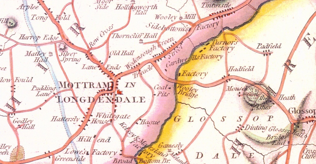
Above photo: Survey map of 1763 showing Padfield on the right
​(Glossop Heritage Trust Photo Archive)

Historic maps of Padfield

One way of learning about the geography of Padfield's past is by studying old historical maps of the area. By today's standards some old maps require a little imagination to piece together the boundaries and other identifying characteristics such as houses, gates and hedges. Some are much easier to read than others. The oldest map of Padfield is the 'Runnat Intack belonging to the Duke,' dated 1763. It's maps such as these, and those from subsequent years, that we hope to include here to give a better understanding of how Padfield's geography has changed over time.
  • Runnat Intack map 1763
  • ​P.P. Burdett's map 1791
  • John Stockdale's Map 1794
  • Poor Law map 1857
Picture
Partial view of John Stockdale's map printed in 1794
COMMUNITY
News
Local Gov.  Reorganisation
Residents' Society
Padfield Community Spaces
Community School
Congregational Chapel
EVENTS & ACTIVITIES
Events & Activities
Padfield Women's Institute
Coal Race
Floral Competition
Padfield Lottery
LOCATION
Books & Publications
Local Wildlife
Longdendale Trail
Conservation Area
Speed Restriction
Useful Contacts
Useful Links
GALLERIES
Padfield's Past
Padfield Today
Padfield Spring
Padfield Winter
Longdendale Snow
HISTORY
Padfield Name Defintion
Brief History of Padfield
Padfield 1901 Census
Old Occupations
Historic Maps
MISCELLANEOUS
Padfield Village News
Guest Book
FIND OUT MORE
About Us

Contributors
Archives
GET IN TOUCH
​Contact Us
​
[email protected]


​
© 2015 - 2023
Padfield Residents' Society.
Padfield, Derbyshire, UK.

  • Home
    • About
    • Contact Us
    • Search
    • Contributors
  • Community
    • News Summer 2025
    • Announcements
    • Local Government Reorganisation
    • Residents' Society
    • Padfield Community Spaces (PCS)
    • Primary School
    • Congregational Chapel
    • Tuesday Club
    • Peels Arms Pub
    • Hadfield with Padfield Wi
    • Support in the Community
  • What's On
    • Events & Activities >
      • Christmas Fayre
      • Coal Race 2024
      • Floral Competition
      • Padfield Lottery
    • Shared Event Calendar
  • Location
    • Local Wildlife
    • Longdendale Trail
    • Conservation Area >
      • Local Green Space
    • Roughfields >
      • About Save Roughfields
    • Speed Restriction
    • Elected Representatives
    • The Local Plan
    • Travel >
      • Bus information
      • Traffic & Roadworks
      • A57 Link Road
      • Rail transport
    • Useful Contacts
    • Useful links
  • History
    • Padfield Name Definition
    • Brief History of Padfield
    • History Timeline
    • Padfield 1901 Census >
      • 1901 Census Transcript
      • Old Occupations & Definitions
    • Historic Maps >
      • Runnat Intack map 1763
      • Burdett's map 1791
      • Stockdale's map 1794
      • Poor Law map 1857
  • Gallery
    • Padfield's Past
    • Padfield Today
    • Padfield Spring
    • Padfield Winter
    • Padfield Snow
    • Local Wildlife
    • Padfield and Environs
    • Longdendale Winter
    • Photo Calendar
  • Publications
  • Guest Book