Padfield Village
  • Home
    • About
    • Contact Us
    • Search
    • Contributors
  • Community
    • News Summer 2025
    • Announcements
    • Local Government Reorganisation
    • Residents' Society
    • Padfield Community Spaces (PCS)
    • Primary School
    • Congregational Chapel
    • Tuesday Club
    • Peels Arms Pub
    • Hadfield with Padfield Wi
    • Support in the Community
  • What's On
    • Events & Activities >
      • Christmas Fayre
      • Coal Race 2025
      • Floral Competition 2025
      • Padfield Lottery
    • Shared Event Calendar
  • Location
    • Local Wildlife
    • Longdendale Trail
    • Conservation Area >
      • Local Green Space
    • Wimberry Hill
    • Roughfields >
      • About Save Roughfields
    • Speed Restriction
    • Elected Representatives
    • The Local Plan
    • Travel >
      • Bus information
      • Traffic & Roadworks
      • A57 Link Road
      • Rail transport
    • Useful Contacts
    • Useful links
  • History
    • Padfield Name Definition
    • Brief History of Padfield
    • History Timeline
    • Padfield 1901 Census >
      • 1901 Census Transcript
      • Old Occupations & Definitions
    • Historic Maps >
      • Runnat Intack map 1763
      • Burdett's map 1791
      • Stockdale's map 1794
      • Poor Law map 1857
  • Gallery
    • Padfield's Past
    • Padfield Today
    • Padfield Spring
    • Padfield Winter
    • Padfield Snow
    • Local Wildlife
    • Padfield and Environs
    • Longdendale Winter
    • Photo Calendar
  • Publications
  • Guest Book

Padfield Community Spaces

Stop Press!


06/05/2025
Padfield Community Spaces has received the first part of our funding from the Government’s Community Ownership Fund (COF). 
This means we can finally start making preparations for taking ownership of the field over the next few months, and you may start to see some activity on the field, as it has to be surveyed and a formal plan has to be prepared.

For more details, see Padfield Community Spaces web site.

About Padfield Community Spaces
Padfield Community Spaces CIO was formed in January 2021 and incorporated in January 2022, to maintain and develop the field at the centre of Padfield village for the use and benefit of the local community and in a sustainable relationship with the environment. The charity aims to maintain a 'green heart' in Padfield, securing it in perpetuity for future generations.
 
For more information visit www.padfieldspaces.com/

Background
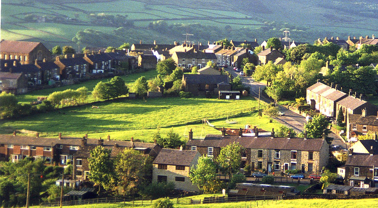
In September 2020, a field which forms part of the quirky ‘Padfield Green Triangle’ - a village landmark and green space at the heart of the Padfield conservation area - was put up for sale.​Villagers were very concerned that the land would not remain a green space if it was sold and wanted to protect it from development for the long term benefit of the village and visitors to the area.
​
In response, a holding company was swiftly formed as a legal vehicle to receive loans and/or donations from local supporters which were made to purchase the field.  A substantial amount of funding was raised by Padfield Open Green Spaces Ltd (POGS) and they successfully secured the field at auction in October 2020.

Since its inception, POGS was established to be a temporary holding company so that the field could be brought into community ownership, once the immediate issue of securing the land was achieved. This would be achieved by forming a second, charitable organisation that could access funding and hold the land in perpetuity.
​
Padfield Community Spaces is the result. It exists to purchase the land from POGS and then to make access and biodiversity improvements in collaboration with any Padfield resident who wishes to take part or have a say.
Picture
COMMUNITY
News
Local Gov.  Reorganisation
Residents' Society
Padfield Community Spaces
Community School
Congregational Chapel
EVENTS & ACTIVITIES
Events & Activities
Padfield Women's Institute
Coal Race
Floral Competition
Padfield Lottery
LOCATION
Books & Publications
Local Wildlife
Longdendale Trail
Conservation Area
Speed Restriction
Useful Contacts
Useful Links
GALLERIES
Padfield's Past
Padfield Today
Padfield Spring
Padfield Winter
Longdendale Snow
HISTORY
Padfield Name Defintion
Brief History of Padfield
Padfield 1901 Census
Old Occupations
Historic Maps
MISCELLANEOUS
Padfield Village News
Guest Book
FIND OUT MORE
About Us

Contributors
Archives
GET IN TOUCH
​Contact Us
​
[email protected]


​
© 2015 - 2023
Padfield Residents' Society.
Padfield, Derbyshire, UK.

  • Home
    • About
    • Contact Us
    • Search
    • Contributors
  • Community
    • News Summer 2025
    • Announcements
    • Local Government Reorganisation
    • Residents' Society
    • Padfield Community Spaces (PCS)
    • Primary School
    • Congregational Chapel
    • Tuesday Club
    • Peels Arms Pub
    • Hadfield with Padfield Wi
    • Support in the Community
  • What's On
    • Events & Activities >
      • Christmas Fayre
      • Coal Race 2025
      • Floral Competition 2025
      • Padfield Lottery
    • Shared Event Calendar
  • Location
    • Local Wildlife
    • Longdendale Trail
    • Conservation Area >
      • Local Green Space
    • Wimberry Hill
    • Roughfields >
      • About Save Roughfields
    • Speed Restriction
    • Elected Representatives
    • The Local Plan
    • Travel >
      • Bus information
      • Traffic & Roadworks
      • A57 Link Road
      • Rail transport
    • Useful Contacts
    • Useful links
  • History
    • Padfield Name Definition
    • Brief History of Padfield
    • History Timeline
    • Padfield 1901 Census >
      • 1901 Census Transcript
      • Old Occupations & Definitions
    • Historic Maps >
      • Runnat Intack map 1763
      • Burdett's map 1791
      • Stockdale's map 1794
      • Poor Law map 1857
  • Gallery
    • Padfield's Past
    • Padfield Today
    • Padfield Spring
    • Padfield Winter
    • Padfield Snow
    • Local Wildlife
    • Padfield and Environs
    • Longdendale Winter
    • Photo Calendar
  • Publications
  • Guest Book