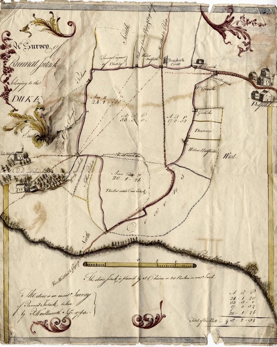
Above photo: Survey map of 1763 showing Padfield on the right
(Glossop Heritage Trust Photo Archive)
(Glossop Heritage Trust Photo Archive)
Survey of Runnat Intack belonging to the Duke
This map, drawn for the Duke of Norfolk, is dated 1763. This is the earliest map showing Padfield. It is beautifully drawn and painted, the colours still vivid, and it has survived in relatively good condition with only minimal wear at the edges and folds.
The word "Intack" comes from an 18th century spelling, possibly from the cartographer/surveyor's local North Derbyshire pronunciation of the word "intake", which is defined as land "taken in" or walled and cultivated from previously open or unfenced common land. It was surveyed by R. Wardleworth, most likely from a Sheffield office of the Howard Estate. It is possible the surveyor started further up the Longdendale Valley and worked south, which could explain why the map appears upside down and back to front. At first glance the locations seem out of place. However, by turning this map upside down and comparing it with a modern-day map OS map, it is easier to pinpoint the different locations and identify the area.
The River Etherow is shown at the bottom, along with the River Mersey. The Etherow is a tributary of the River Goyt, which in turn is a tributary of the Mersey so whilst the map is not entirely accurate, water from the Etherow does eventually flow into the Mersey. It is interesting to know that householders are named, such as: Coopers, Hadfields, Roberts, Garlicks and Doxons, depicting various-sized plots of land along with trees, buildings and field gates, all used in the surveying of the land.
Map courtesy of Glossop Heritage Trust
In the centre of the map you will notice the letters A.R.P. and three sets of numbers in four different areas. These show the area of land in Acres, Roods and Poles (often referred to as pole or perch in land measurement). Using the definitions below you will get an idea of the size of the land where these have been recorded.
The dotted lines are paths/roads connecting Beeley Clough and Blackshaw Clough from Old Glossop (as the map is pre Howard town) and the straight line running through the middle of the map is the current Woodhead Road from Glossop. Also shown are the identifiable areas of Deep Clough, Ogden Clough and Peak Naze. Using these outer locations as a positioning device, we can roughly place the present day Windy Harbour at the centre of the map.
For a larger version of the map, right-click the file below and select "open link in new tab". This will open the full-sized image in another tab where you should be able to zoom in and out if your browser is capable.
- Acre = 4 roods = 10 sq chains = 4,840 sq yards
- Rood = ¼ Acre = 1,210 sq yards = 40 sq poles
- Pole = 30¼ sq yards
The dotted lines are paths/roads connecting Beeley Clough and Blackshaw Clough from Old Glossop (as the map is pre Howard town) and the straight line running through the middle of the map is the current Woodhead Road from Glossop. Also shown are the identifiable areas of Deep Clough, Ogden Clough and Peak Naze. Using these outer locations as a positioning device, we can roughly place the present day Windy Harbour at the centre of the map.
For a larger version of the map, right-click the file below and select "open link in new tab". This will open the full-sized image in another tab where you should be able to zoom in and out if your browser is capable.
| Runnat Intack (Padfield-1763).jpg |