Padfield Village
  • Home
    • About
    • Contact Us
    • Search
    • Contributors
  • Community
    • News Summer 2025
    • Announcements
    • Local Government Reorganisation
    • Residents' Society
    • Padfield Community Spaces (PCS)
    • Primary School
    • Congregational Chapel
    • Tuesday Club
    • Peels Arms Pub
    • Hadfield with Padfield Wi
    • Support in the Community
  • What's On
    • Events & Activities >
      • Christmas Fayre
      • Coal Race 2025
      • Floral Competition 2025
      • Padfield Lottery
    • Shared Event Calendar
  • Location
    • Local Wildlife
    • Longdendale Trail
    • Conservation Area >
      • Local Green Space
    • Wimberry Hill
    • Roughfields >
      • About Save Roughfields
    • Speed Restriction
    • Elected Representatives
    • The Local Plan
    • Travel >
      • Bus information
      • Traffic & Roadworks
      • A57 Link Road
      • Rail transport
    • Useful Contacts
    • Useful links
  • History
    • Padfield Name Definition
    • Brief History of Padfield
    • History Timeline
    • Padfield 1901 Census >
      • 1901 Census Transcript
      • Old Occupations & Definitions
    • Historic Maps >
      • Runnat Intack map 1763
      • Burdett's map 1791
      • Stockdale's map 1794
      • Poor Law map 1857
  • Gallery
    • Padfield's Past
    • Padfield Today
    • Padfield Spring
    • Padfield Winter
    • Padfield Snow
    • Local Wildlife
    • Padfield and Environs
    • Longdendale Winter
    • Photo Calendar
  • Publications
  • Guest Book

Local Green Space

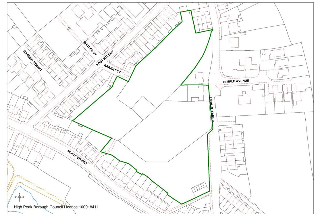
In the 2014 High Peak Local Plan, an area at the heart of Padfield - the "Triangle" - was formally designated as a Local Green Space.
The boundary of the Local Green Space is shown in green on the map below:

Background
The National Planning Policy Framework (NPPF), published by the Department for Communities and Local Government in March 2012 and most recently updated in July 2021, sets out the government’s planning policies for England.  Paragraphs 101 to 103 introduce a Local Green Space designation (LGS) to protect local green areas of special importance to local communities.

This enables communities, in particular circumstances, to identifyand protect areas that are of value to them through local and neighbourhood plans.  Local Greeen Space status is designated by the planning authority (High Peak Borough Council, in our case). Once the designation is in place, the area is subject to the same strong development restrictions as Green Belt, ruling out new development except in special circumstances.
Picture

COMMUNITY
News
Local Gov.  Reorganisation
Residents' Society
Padfield Community Spaces
Community School
Congregational Chapel
EVENTS & ACTIVITIES
Events & Activities
Padfield Women's Institute
Coal Race
Floral Competition
Padfield Lottery
LOCATION
Books & Publications
Local Wildlife
Longdendale Trail
Conservation Area
Speed Restriction
Useful Contacts
Useful Links
GALLERIES
Padfield's Past
Padfield Today
Padfield Spring
Padfield Winter
Longdendale Snow
HISTORY
Padfield Name Defintion
Brief History of Padfield
Padfield 1901 Census
Old Occupations
Historic Maps
MISCELLANEOUS
Padfield Village News
Guest Book
FIND OUT MORE
About Us

Contributors
Archives
GET IN TOUCH
​Contact Us
​
[email protected]


​
© 2015 - 2023
Padfield Residents' Society.
Padfield, Derbyshire, UK.

  • Home
    • About
    • Contact Us
    • Search
    • Contributors
  • Community
    • News Summer 2025
    • Announcements
    • Local Government Reorganisation
    • Residents' Society
    • Padfield Community Spaces (PCS)
    • Primary School
    • Congregational Chapel
    • Tuesday Club
    • Peels Arms Pub
    • Hadfield with Padfield Wi
    • Support in the Community
  • What's On
    • Events & Activities >
      • Christmas Fayre
      • Coal Race 2025
      • Floral Competition 2025
      • Padfield Lottery
    • Shared Event Calendar
  • Location
    • Local Wildlife
    • Longdendale Trail
    • Conservation Area >
      • Local Green Space
    • Wimberry Hill
    • Roughfields >
      • About Save Roughfields
    • Speed Restriction
    • Elected Representatives
    • The Local Plan
    • Travel >
      • Bus information
      • Traffic & Roadworks
      • A57 Link Road
      • Rail transport
    • Useful Contacts
    • Useful links
  • History
    • Padfield Name Definition
    • Brief History of Padfield
    • History Timeline
    • Padfield 1901 Census >
      • 1901 Census Transcript
      • Old Occupations & Definitions
    • Historic Maps >
      • Runnat Intack map 1763
      • Burdett's map 1791
      • Stockdale's map 1794
      • Poor Law map 1857
  • Gallery
    • Padfield's Past
    • Padfield Today
    • Padfield Spring
    • Padfield Winter
    • Padfield Snow
    • Local Wildlife
    • Padfield and Environs
    • Longdendale Winter
    • Photo Calendar
  • Publications
  • Guest Book