Padfield Village
  • Home
    • About
    • Contact Us
    • Search
    • Contributors
  • Community
    • News Summer 2025
    • Announcements
    • Local Government Reorganisation
    • Residents' Society
    • Padfield Community Spaces (PCS)
    • Primary School
    • Congregational Chapel
    • Tuesday Club
    • Peels Arms Pub
    • Hadfield with Padfield Wi
    • Support in the Community
  • What's On
    • Events & Activities >
      • Christmas Fayre
      • Coal Race 2024
      • Floral Competition
      • Padfield Lottery
    • Shared Event Calendar
  • Location
    • Local Wildlife
    • Longdendale Trail
    • Conservation Area >
      • Local Green Space
    • Roughfields >
      • About Save Roughfields
    • Speed Restriction
    • Elected Representatives
    • The Local Plan
    • Travel >
      • Bus information
      • Traffic & Roadworks
      • A57 Link Road
      • Rail transport
    • Useful Contacts
    • Useful links
  • History
    • Padfield Name Definition
    • Brief History of Padfield
    • History Timeline
    • Padfield 1901 Census >
      • 1901 Census Transcript
      • Old Occupations & Definitions
    • Historic Maps >
      • Runnat Intack map 1763
      • Burdett's map 1791
      • Stockdale's map 1794
      • Poor Law map 1857
  • Gallery
    • Padfield's Past
    • Padfield Today
    • Padfield Spring
    • Padfield Winter
    • Padfield Snow
    • Local Wildlife
    • Padfield and Environs
    • Longdendale Winter
    • Photo Calendar
  • Publications
  • Guest Book

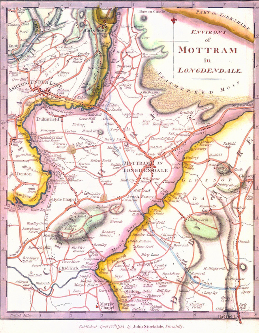
John Stockdale's map of 1794

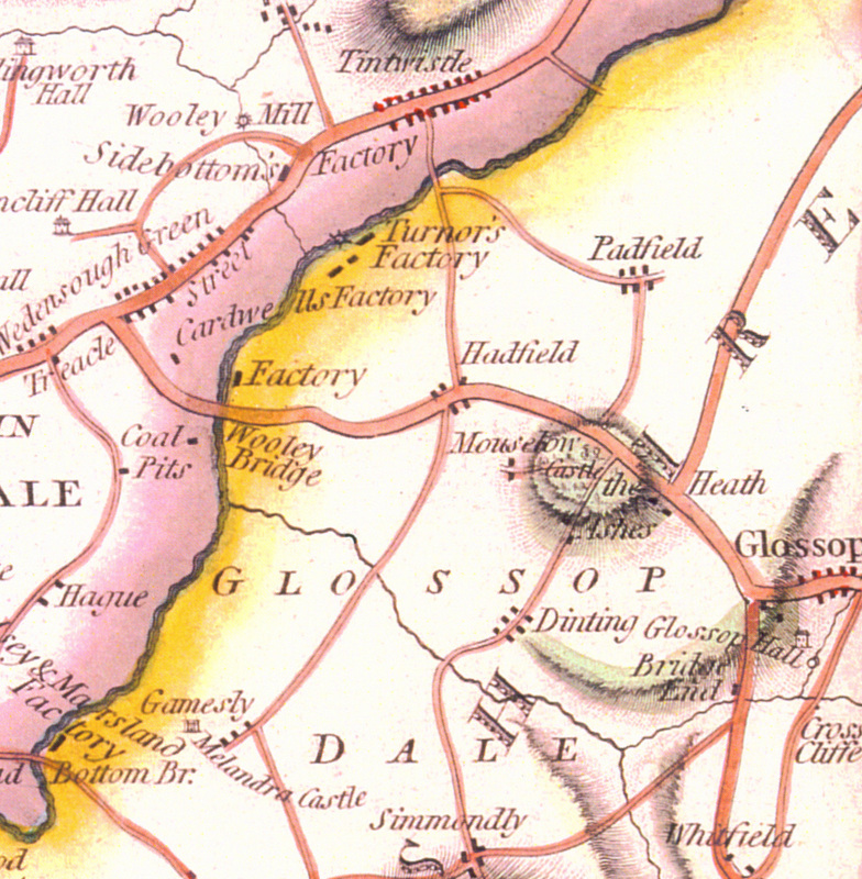
This map shows part of the 'Environs of Mottram in Longdendale,' published on 12 April, 1794. The first image has been cropped around the area of Padfield. It clearly shows a few dwellings located on Padfield Main Road, the upper part leading to the Woodhead Road, which has not yet been constructed. Padfield Main Road connects another road, presumably lines roughly following Temple Street and Redgate, with that of Park Road that leads through the then small village of Hadfield, which is prominently marked along with Tintwistle and Hollingworth, both being larger entities containing more dwellings. This section of the map bears a striking resemblance to Burdett's map of 1791, with the addition of colour and detail on northern and western side of the Etherow.

The boundary between Derbyshire and Cheshire are clearly visible by use of colour either side of the River Etherow, marked with a thick black line. The pink side is Cheshire and the yellow side is Derbyshire. The reservoirs have not yet been constructed, the first of which will be the Woodhead Reservoir in August 1848, followed by Rhodeswood, Torside, Anfield and Hollingworth reservoirs between in 1849. Valehouse and Bottoms are later additions with construction commencing in July 1865 and November 1867 respectively. 

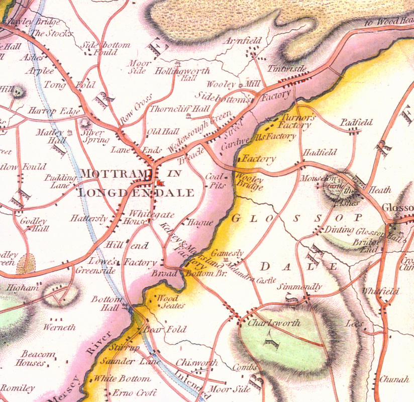
The second of these three maps show the importance of Mottram in Longdendale in the area. Being larger than any other neighbouring village, it's size equalled that of Ashton-under-Lyne.
Picture
Map courtesy of Glossop Heritage Trust
Picture
Map courtesy of Glossop Heritage Trust
Picture
Map courtesy of Glossop Heritage Trust
COMMUNITY
News
Local Gov.  Reorganisation
Residents' Society
Padfield Community Spaces
Community School
Congregational Chapel
EVENTS & ACTIVITIES
Events & Activities
Padfield Women's Institute
Coal Race
Floral Competition
Padfield Lottery
LOCATION
Books & Publications
Local Wildlife
Longdendale Trail
Conservation Area
Speed Restriction
Useful Contacts
Useful Links
GALLERIES
Padfield's Past
Padfield Today
Padfield Spring
Padfield Winter
Longdendale Snow
HISTORY
Padfield Name Defintion
Brief History of Padfield
Padfield 1901 Census
Old Occupations
Historic Maps
MISCELLANEOUS
Padfield Village News
Guest Book
FIND OUT MORE
About Us

Contributors
Archives
GET IN TOUCH
​Contact Us
​
[email protected]


​
© 2015 - 2023
Padfield Residents' Society.
Padfield, Derbyshire, UK.

  • Home
    • About
    • Contact Us
    • Search
    • Contributors
  • Community
    • News Summer 2025
    • Announcements
    • Local Government Reorganisation
    • Residents' Society
    • Padfield Community Spaces (PCS)
    • Primary School
    • Congregational Chapel
    • Tuesday Club
    • Peels Arms Pub
    • Hadfield with Padfield Wi
    • Support in the Community
  • What's On
    • Events & Activities >
      • Christmas Fayre
      • Coal Race 2024
      • Floral Competition
      • Padfield Lottery
    • Shared Event Calendar
  • Location
    • Local Wildlife
    • Longdendale Trail
    • Conservation Area >
      • Local Green Space
    • Roughfields >
      • About Save Roughfields
    • Speed Restriction
    • Elected Representatives
    • The Local Plan
    • Travel >
      • Bus information
      • Traffic & Roadworks
      • A57 Link Road
      • Rail transport
    • Useful Contacts
    • Useful links
  • History
    • Padfield Name Definition
    • Brief History of Padfield
    • History Timeline
    • Padfield 1901 Census >
      • 1901 Census Transcript
      • Old Occupations & Definitions
    • Historic Maps >
      • Runnat Intack map 1763
      • Burdett's map 1791
      • Stockdale's map 1794
      • Poor Law map 1857
  • Gallery
    • Padfield's Past
    • Padfield Today
    • Padfield Spring
    • Padfield Winter
    • Padfield Snow
    • Local Wildlife
    • Padfield and Environs
    • Longdendale Winter
    • Photo Calendar
  • Publications
  • Guest Book